 A cloudburst is an extreme weather event defined by an extremely heavy, sudden downpour of rain over a small area in a short period of time. ⛈️ The India Meteorological Department (IMD) defines a cloudburst as rainfall exceeding 100 millimeters (about 4 inches) in one hour over a geographical area of approximately 20 to 30 square kilometers.
Cloudbursts are particularly destructive because of the sheer volume and speed of the water, which can trigger flash floods, landslides, and mudslides. While the term “cloudburst” suggests a cloud “bursting” open, the phenomenon is caused by specific meteorological conditions.
How Cloudbursts Happen
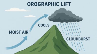
Cloudbursts often occur in hilly or mountainous regions due to a process called orographic lift. This happens when warm, moisture-laden air is forced to rise as it encounters a mountain slope. As the air rises to higher altitudes with lower atmospheric pressure, it expands and cools. This causes the water vapor to condense rapidly, forming large, vertically developed clouds known as cumulonimbus clouds.
Within these clouds, strong updrafts of air can suspend water droplets and ice particles, preventing them from falling as normal rain. This allows a massive amount of moisture to accumulate. When the updrafts suddenly weaken or the droplets become too heavy, all the accumulated water is released at once, resulting in a sudden and intense downpour. The fast-moving water flowing down steep slopes can carry debris and boulders, causing widespread destruction.